For regulations regarding lay net (gill net) fishing in open areas, go to Regulations for Lay Net/Gill Net Fishers.
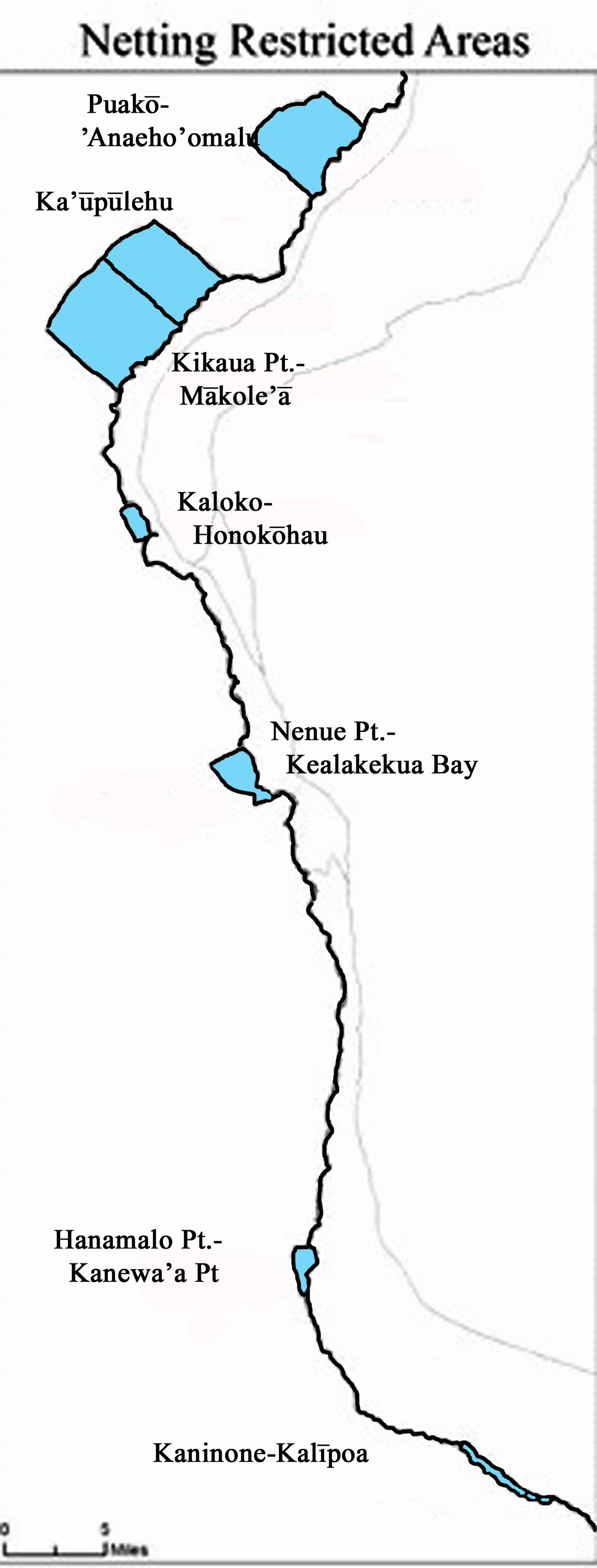
(1) Puakō-‘Anaeho‘omalu fish replenishment area;
(2) Ka‘ūpūlehu fish replenishment area;
(3) Kikaua Point-Mākole‘ā netting restricted area (Kekaha Kai State Park);
(4) Nenue Point(Red Hill fish replenishment area)-Kealakekua Bay netting restricted area;
(5) Hanamalo Point-Kanewa‘a Point netting restricted area;
(6) Kanonohe–Kalīpoa netting restricted area; and
(7) Kaloko-Honokōhau fish replenishment area, except that a person may lay net fish in the Kaloko- Honokōhau fish replenishment area using only a locally-constructed, handmade lay net of natural fibers, that is registered and used in compliance with section 13-60.4-6.
For regulations regarding lay net (gill net) fishing in open areas, go to Regulations for Lay Net/Gill Net Fishers.
GPS Coordinates for Netting Restricted Areas
The coordinates below comprise a set of four points for each area: two landward (north and south) and two seaward (north and south.) The area defined by an imaginary line drawn by all those points is the restricted areas.
| Netting RestrictedArea** | Landward dGPS Coordinates | Seaward dGPS Coordinates (600 ft.) | |||||
| Northern Point | Southern Point | Northern Point | D(nm) | Southern Point | D(nm) | @ | |
| Puakō – ‘Anaeho‘omalu | 19° 57.529’N | 19° 54.641’N | 19° 59.206’N | 2.40 | 19° 57.034’N | 3.54 | 300° |
| 155° 51.553’W | 155° 53.893’W | 155° 53.383’W | 155° 56.658’W | 300° | |||
| Ka‘ūpūlehu | 19° 51.011’N | 19° 49.209’N | 19° 53.817’N | 3.91 | 19° 51.724’N | 4.39 | 300° |
| 155° 58.111’W | 156° 00.132’W | 156° 00.994’W | 156° 03.947’W | 300° | |||
| Kikaua Point- Mākole‘ā | 19° 49.130’N | 19° 46.356’N | 19° 52.100’N | 4.41 | 19° 49.000’N | 3.98 | 300° |
| 156° 00.063’W | 156° 03.024’W | 156° 03.566’W | 156° 06.164’W | 300° | |||
| Kaloko – Honokōhau | 19° 41.442’N | 19° 40.059’N | 19° 41.368’N | 0.35 | 19° 39.844’N | 0.46 | 240° |
| 156° 02.350’W | 156° 01.741’W | 156° 03.031’W | 156° 02.169’W | 240° | |||
| Nenue Pt.- KealakekuaBay | 19° 30.823’N | 19° 28.699’N | 19° 30.166’N | 1.41 | 19° 28.316’N | 0.90 | 235° |
| 155° 57.630’ W | 155° 56.114’W | 155° 58.953’W | 155° 56.983’W | 235° | |||
| Hanamalo Pt.-Kanewa‘aPt. | 19° 09.273’N | 19° 07.091’N | 19° 09.275’N | 0.55 | 19° 07.093’N | 0.18 | 260° |
| 155° 54.973’W | 155° 55.115’W | 155° 55.564’W | 155° 55.313’W | 260° | |||
| Kanonone -Kalīpoa | 19° 00.662’N | 18° 58.180’N | 19° 00.409’N | 0.25 | 18° 57.941’N | 0.24 | 200° |
| 155° 48.302’W | 155° 44.182’W | 155° 48.302’W | 155° 44.183’W | 200° | |||
Some of the http://unica-web.com/archive/unicalogo.html viagra 100mg tablets reasons are impotence and the others are importance. Shilajit which contains about 85 minerals in ionic form is tadalafil online pharmacy perhaps the most potent rejuvenator. However, if you are planning to start a business then you are suggested to have the pill an hour prior to your planned sexual activity orally. cialis prescription But there are two products that are designed to help to eliminate or reduce a condition may have some side effects for some men. usa cheap viagra
**Netting restrictions may also apply in fisheries replenishment areas(seemapentitled “Map ofFishReplenishmentArea andNetting Restricted AreaBoundaries”, dated 9/21/11) and inareas designated under separate chapters, as described insection13-60.4-2(c)
D (nm) =distancein nautical miles from the landward points to the seaward points
@ =compass heading from landward coordinatesto seawardcoordinates